Trail Other activity Saint-Martin (VS) - VS - La Maya (cab. Becs de Bosson), Vallon de Réchy - Photo

VS - La Maya (cab. Becs de Bosson), Vallon de Réchy

© OpenStreetMap contributors
Length
Length
16.7 km
Max alt
Max alt
3002 m
Uphill gradient
Uphill gradient
1552 m
Km-Effort
Km-Effort  
37 km
Min alt
Min alt
1627 m
Downhill gradient
Downhill gradient
1568 m
Boucle
Boucle
Yes
Creation date :
2014-12-11 00:00:00.0
Updated on :
2014-12-11 00:00:00.0

(0 Reviews)

Other activity
Other activity
--
Difficulty : Unknown

Scan this QR Code to open this trail in the SityTrail application

FREE GPS app for hiking

Logo SityTrail SityTrail

IGN / Geographical institutes

Download SityTrail from the App Store Download SityTrail from Google Play

Logo SityTrail SityTrail World

The world is yours!

Download SityTrail from the App Store Download SityTrail from Google Play Download SityTrail on Huawei AppGallery

About

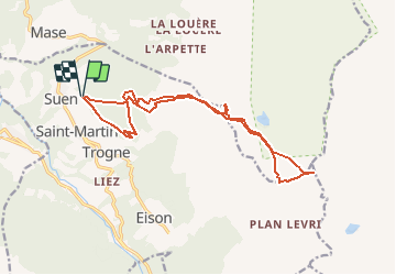
Trail Other activity of 16.7 km to be discovered at Valais/Wallis, Hérens, Saint-Martin (VS). This trail is proposed by sterrettaz.

Description

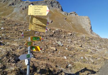
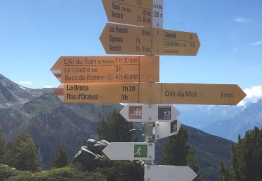
Montée depuis Suen (également possible depuis le sommet des installations de NAX) en direction de la cabane des BECS DE BOSSON.
Ce tracé passe aussi par le Bec de Lovegno et la Pointe de Tsavolire.
Il a a d''innombrables autres possibilités dans le secteur (Vercorin, Grimentz, côté Nax, Mt-Gauthier, Mt Noble, La Vieille -> Pas de Lona, ...)

Elevation profile

Positioning

Country:
Switzerland
Region :
Valais/Wallis
Department/Province :
Hérens
Municipality :
Saint-Martin (VS)
Location:
Unknown
Start:(UTM)
379929 ; 5115323 (32T) N.

Trails nearby

Trail On foot Hérémence - Euseigne - fixme - Photo
On foot
PRO

On foot

Easy
Hérémence, Valais/Wallis, Hérens, Switzerland
3.2 km | 6.2 km-effort
1h 25min
No
Trail On foot Hérémence - Euseigne - Hérémence - Photo
On foot
PRO

On foot

Easy
Hérémence, Valais/Wallis, Hérens, Switzerland
5.2 km | 9.7 km-effort
2h 12min
No
Trail On foot Mont-Noble - La Combe - Nax - Photo
On foot
PRO

On foot

Easy
Mont-Noble, Valais/Wallis, Hérens, Switzerland
6.3 km | 9.8 km-effort
2h 13min
No
Trail On foot Mont-Noble - Le Louché Lac - Col du Cou - Photo
On foot
PRO

On foot

Easy
Mont-Noble, Valais/Wallis, Hérens, Switzerland
3.7 km | 6.3 km-effort
1h 26min
No
Trail On foot Mont-Noble - Le Louché-L'Ar du Tsan Lac (A) - Photo
On foot
PRO

On foot

Easy
Mont-Noble, Valais/Wallis, Hérens, Switzerland
3.6 km | 5 km-effort
1h 8min
No
Trail Nordic walking Hérémence - vallée de la borgne - Photo
Nordic walking
suzanne.bron

Nordic walking

Very easy
Hérémence, Valais/Wallis, Hérens, Switzerland
10.8 km | 15.4 km-effort
5h 22min
No
Trail Walking Saint-Martin (VS) - Trajet du 28.10.21 - Photo
Walking
Leemans

Walking

Very difficult
Saint-Martin (VS), Valais/Wallis, Hérens, Switzerland
14.8 km | 28 km-effort
6h 17min
Yes
Trail Walking Mont-Noble - Crêts du Midi au lac Le Louché - Photo
Walking
jpksenicz

Walking

Difficult
Mont-Noble, Valais/Wallis, Hérens, Switzerland
7.3 km | 11.3 km-effort
1h 28min
No
Trail Walking Vex - Les Collons - Photo
Walking
cmike39

Walking

Medium
Vex, Valais/Wallis, Hérens, Switzerland
12.1 km | 18.8 km-effort
4h 9min
Yes


Close
My subscriptions